ENLIGHT
Enabling the analysis of global urban heat
Project by: Benjamin Bechtel, Matthias Demuzere, Panagiotis Sismanidis, Jonas Kittner, Daniel Fenner
Timing: Apr 2020–Sep 2023
Project website: https://www.geographie.ruhr-uni-bochum.de/klima/enlight.html
Contact: enlight-project@ruhr-uni-bochum.de
Funded by: German Research Foundation (DFG)
Development of a global urban (LCZ) database
Based upon extensive knowledge about deriving LCZ maps from remote-sensing products and creating continental-scale LCZ maps, the ambition is to produce a high-resolution and high-quality global LCZ map for application in (urban) climate investigations. The map shall be based on various remote sensing products and crowdsourced collection of global LCZ training data. In addition, an open, online, cloud-based dashboard for LCZ classification will be developed to allow users to rapidly map their city of choice using more specific training data or specific LCZ-subclasses.

Development of an urban thermal effect database
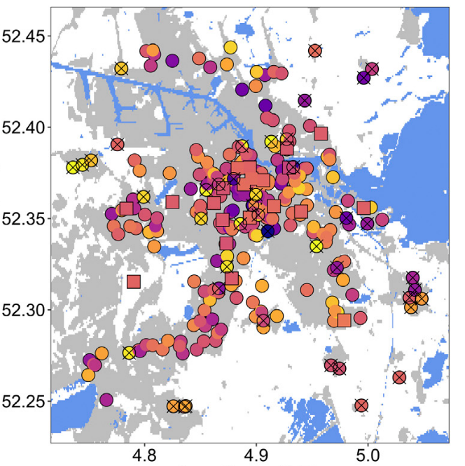
Work package 2 aims at gathering spatially explicit patterns of surface and canopy-layer urban heat islands (UHI) for numerous cities world-wide. Local-scale surface UHI will be derived from Landsat and MODIS land-surface temperatures, and their diurnal and annual variation will be analysed for >1000 cities. Local-scale canopy-layer UHI shall be derived from crowdsourced air temperature data from citizen weather stations (CWS). These data will undergo rigorous quality-control and be compared to professionally-measured atmospheric data. A workflow will be developed to consistently update these data for near real-time analyses.
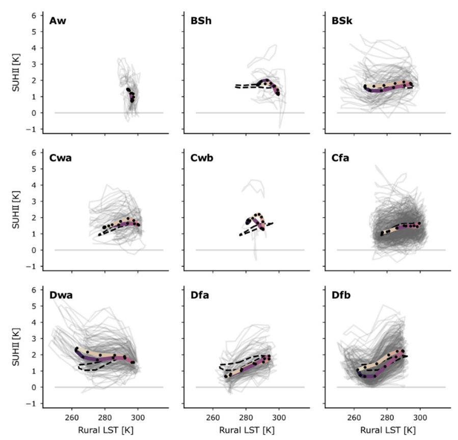
Assessment of the urban heat island characteristics of cities
In this work package, the intra- and inter-urban surface and canopy-layer urban heat islands (UHI) will be compared in different background climates and investigate influencing factors, e.g., meteorology, topography, and land cover. Analyses shall be based on data acquired in work packages 1 and 2 on local-scale surface characteristics (Local Climate Zones), and land-surface temperature and canopy-layer air temperature, respectively. Due to the selected methodology and data, a consistent comparison of UHI intensities and their influencing factors can be achieved.
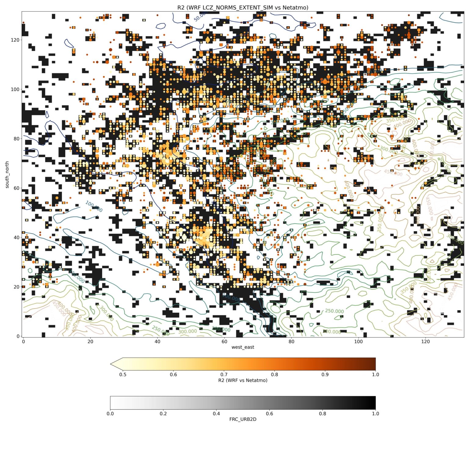
Evaluation of urban modelling tools
This final work package aims at demonstrating the added value of Local Climate Zones as input for urban canopy models in urban climate modelling. Input data from work package 1 (Local Climate Zone maps and derived surface characteristics) shall be used as input for different models. The models shall comprehensively be evaluated for selected cities in the thermal database from work package 2, using the acquired data of land-surface and air temperature. The goal is to demonstrate the added value of integrating local-scale surface information in urban climate modelling in different background climates and city settings.
References
- Demuzere M, Kittner J, Bechtel B. LCZ Generator (2021): A Web Application to Create Local Climate Zone Maps. Front Environ Sci. 2021: 9. https://doi.org/10.3389/fenvs.2021.637455
- Fenner D, Bechtel B, Demuzere M, Kittner J, Meier F. (2021): CrowdQC+—A Quality-Control for Crowdsourced Air-Temperature Observations Enabling World-Wide Urban Climate Applications. Front Environ Sci. 2021: 9:1-21. https://doi.org/10.3389/fenvs.2021.720747
- Demuzere, M., Kittner, J., Martilli, A., Mills, G., Moede, C., Stewart, I. D., van Vliet, J., and Bechtel, B. (2022). A global map of Local Climate Zones to support earth system modelling and urban scale environmental science. Earth System Science Data, 14 3835–3873. http://doi.org10.5194/essd-14-3835-2022
- Sismanidis, P., Bechtel, B., Perry, M., Ghent, D. (2022). The Seasonality of Surface Urban Heat Islands across Climates. Remote sensing, 14(10), 2318. https://doi.org/10.3390/rs14102318